

Sir Francis Drake in Point Roberts?
DRAKE, NEW ALBION AND BOUNDARY BAY
By Warren Stevenson, Point Roberts Historical Society
Was Drake's ship, the Golden Hinde, in (and out of) the waters of Boundary Bay? If so, for how long and when? The answer to the first question increasingly seems to be "Probably", and to the second and easier of the two questions, "For approximately five weeks, from June 17, to July 23, 1579." What were Drake and his crew doing here? Among other things, careening-- a nautical term which means tipping over to one side for cleaning, caulking, and so forth-- their now famous ship, preparatory to sailing it across the Pacific back to its home port in Plymouth, England.
To my knowledge, the first person to seriously contend that Drake might have careened the Golden Hinde on the shores of Boundary Bay was the late Will Paulik, a local historian and environmentalist who, according to the article by Jan Westell in the Delta Optimist, dated August 19,2000, "About five years ago presented a theory to the Delta Historical Society that Drake may have sailed into Boundary Bay loaded with treasure from the Spanish, to careen his ship." I was fortunate enough to get to know Will shortly before the article appeared as I became a member of his newly formed Pacific Coast Exploration Society in order to learn more about these matters from Him and his assistant, Ralph Heading (1).
Will based his theory on the close resemblance between Boundary Bay and the map of "Portus Nova Albion," published by a Dutch mapmaker named Hondius who had visited England and consulted with Drake. This map of New Albion is placed in the upper left-hand corner of Hondius' much larger broadside of the world. Well known to Drake researchers, it is conveniently reproduced in The Secret Voyage of Sir Francis Drake 1577-1580, the second of two books on this subject by Samuel Bawlf. The Drake/Hondius map (as it may be called) shows a well formed, sheltered bay that looks much like Boundary Bay when allowance is made, as Will observed, for the tidal spit shown on the west side of the unnamed point, most likely being the now submerged Roberts Bank. Yet, oddly enough, Bawlf never considers the possibility of Boundary Bay as the venue of Drake's New Albion and careenage.
Bawlf's main thesis, which is stated as fact in the Encyclopedia Britannica, 1962, but for which he presents interesting new evidence, is that when Drake set sail from Plymouth on December 13, 1577 with five ships supposedly heading for the Mediterranean, he had secret instructions from the Queen to sail in the opposite direction to raid Spanish treasure ships and towns, and to find the western exit of the northwest passage, as well as a possible site for an English Colony. Because of the maritime rivalry between England and Spain at this time, Drake's purpose had to be kept secret.
Immediately after sailing through the treacherous Straits of Magellan, Drake ran into a terrific storm, which irretrievably separated him from his escort ships; two were already lost, and of the remainder, one was wrecked and the other turned back. The Golden Hinde was blown of course far south past Tierra del Fuego-- which Drake proved an island and discovered a new "southern passage" that bears his name. Only by extreme tenacity and perseverance was he able to reach the calmer waters of the Pacific. Heading northward, Drake made several hit and run raids on Spanish colonial towns along the west coast of South and Central America, amassing a vast amount of treasure for the crown. The nimble Golden Hinde easily eluded her more cumbersome pursuers.
Bawlf maintains that Drake sailed as far north as the Alaska panhandle, citing such details as the extreme cold he and his men endured. The likelihood of this has until recently been obscured by Drake's apparent alteration of his northern latitudinal readings-- all those beyond what Bawlf calls his "northern reach", or cap, of 48 degrees-- in accord with his "secret instructions" intended to confuse the Spaniards in the event of capture. Drake's missing log was evidently sequestered on Queen Elizabeth's orders upon his return, and she seemingly requested a vow of silence. In addition, a general "gag order" was imposed, but gradually relaxed as time went on, permitting others to capitalize on their accounts of the voyage, for which researchers may be grateful.
In the most important of these, Fletcher's (2) shipboard diary eventually published in a book called The World Encompassed, (1968), he mentions the "sparkling white bancks and cliffes" of New Albion, which "lie toward the sea" and by virtue of "some affinity"... with out own country" suggested its name to Drake. "Albion", an old mythic name for England, derives from the Latin "albus" meaning white, because the white cliffs of Dover were for most foreign arrivals their first site of England. One may compare the beautiful white cliffs of aptly named Lily Point, remarked on by regional historian Richard E. Clark and others, which serve as a landmark for mariners approaching Point Roberts to this day.
What else, besides careening the Golden Hinde, occupied Drake and his men at New Albion? Fletcher says that they fraternized with the local natives who regarded them as "gods" and crowned Drake as one of their kings. The native dwellings were conical pit houses, with the entrance and exit through a smoke hole in the roof, (see Bawlf, p 321), similar to those of the Coast Salish Indians. Drake and his crew set up a portable blast furnace, as indicated in a tiny drawing on the Drake/Hondius map, to repair and refurbish their tools and weapons, as well as the melting of tar for caulking. Will Paulik discovered a quantity of old slag near the customs crossing and speculated that it just might have come from one of those portable furnaces. Fletcher also states that before departure, Drake claimed the whole area for the Queen and nailed a brass plaque to a tree bearing an inscription confirming this, as was his custom. The knowledge of this practice has led to exciting finds that have turned out to be deception.
One plausible find was north of San Francisco. That imposter seems to have arisen because Fletcher's diary and the other published accounts give 38.30 lat. -- just north of San Francisco-- for the careenage. However, according to Bawlf's ten degree "add-on" rule necessitated to correct Drake's stratagem of the "northern reach", 38.3o degrees becomes 48.30 degrees which happens to compare favorably to the northwest tip of the Olympic Peninsula. Bawlf calls this Drake's Point of Position because supply ships would round this cape in order to enter the Strait of Juan de Fuca. Bawlf affirms that here Drake took the latitudinal reading which established his navigational landmark for the future colony. This would apply regardless of whether, as Bawlf argues, New Albion was located at Comox Bay on the east coast of Vancouver Island-- not withstanding that the Drake/Hondius map shows a bay facing the southwest-- or as I (Warren Stevenson) maintain, at Boundary Bay which presents no such difficulty.
After locating New Albion at Comox Bay, Bawlf relocates the site of careenage to Whale Cove, Oregon, although estimates of Fletcher, John Drake and others maintain that careenage was done at New Albion. In an article on the Internet, Raymond Aker (3) analyzes the use of "The Anonymous Narrative" of Drake's major voyage to bolster Bawlf's claim for Whale Cove as the site of Drake's careenage. Aker asks why, after his exploration further north, should Drake have neglected better harbors en route to "settle for tiny, dangerous Whale Cove." (Aker p.4) Aker also disagrees with Bawlf's interpretation of a part of the deposition of John Drake, who, according to Bawlf, told the Spaniards that Drake named "the largest and best of the islands Nova Albion." (4) Aker continues: "What John actually said was 'Captain Drake gave the land, which lies in forty-eight degrees, the name of Nova Albion. (Aker, p.5 ; compare with Bawlf, pp 205-207, 224.) He did not say it was an island!"
Unmentioned by Bawlf is the fact that the Drake/Hondius map is confirmed and even enhanced with additional features by a map based on a freehand drawing that is reproduced in Robert Dudley's "Dell' Arcano del Mare," published in Florence (1647). Fig. 2 This map has its own handwritten inscriptions that may have been added by Dudley, including "La Punta" where present day Point Roberts is located and "B. (Baia=Bay?) Di Nova Albion" at the head of the bay, where the delta mudflats are now. To the east of the bay-- a stylized singular large mountain (Mount Baker?) in lieu of the large one flanked by smaller ones in the Drake/Hondius map, as well as two small rivers close to one another flowing westward into the bay (compare the Nickomekl and the Serpentine, both near Crescent Beach.) In the lower right hand corner is a projecting "C. de Nuova Albion", located approximately, where the present day Birch Cape is. Whoever drew this map, which Drake may have given Dudley before he left England for Italy, must have been aboard the Golden Hinde. My guess is that it must have been Francis Drake's young cousin, John Drake.
One may conclude that the location of New Albion on Vancouver Island is evidently a misinterpretation based on the misreading of John Drake's deposition. The deposition strengthens the case for establishing Boundary Bay as the site of both New Albion and the careenage of the Golden Hinde, as it is in more accord with the available evidence. The defense rests!
PORTUS PLAN "Portus Nova Albion"- Hondius


Robert Dudley's "Dell' Arcano del Mare," published in Florence (1647)

CURRENT AERIAL PHOTO OF POINT ROBERTS
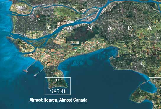
Landsat image by Robert Stacey, WorldSat International Inc. - National Geographic, August 2004
Footnotes:
(1) Ralph Heading is the current head of the Pacific Coast Exploration Society also featured speaker at the April meeting of Point Roberts Historical Society.
(2) Francis Fletcher, Cambridge educated, served as Captain for the voyage, kept a written and illustrated diary of the voyage.
(3) Raymond Aker, Internet "Analysis of Samuel Bawlf's Secret Francis Drake Mission to Discover the Northwest Passage."
(4) John Drake, cousin of Sir Francis, was an accomplished artist and assistant mapmaker on the Great Voyage. He was taken prisoner on a later voyage and gave his deposition to the Inquisition in 1584-1587. Aker is relying on the official transcript of this, Bawlf is relying on a presumed later version by the Spanish historian, Antonio de Herrara, pub. 1606.
posted by Jen @ 9:28 PM
![]()
![]()
3 Comments:
Pretty silly.
Read "Port of the Dragon, The Lost Harbor of Sir Francis Drake,
Drake landed in three different bays in Northwest Washington State, the first of which
was Birch Bay.
This article was posted in 2005. Since then Ralph Heading has now recanted everything in this article which pertains to identifying the so-called landsite. He agrees that Nehalem Bay and Neahkahnie Mountain, Oregon as Drake's landing site and the land claim he laid out on the countryside of neighboring Neahkahnie Mountain. www.FortNehalem.net
Post a Comment
<< Home